
(The first in a series on Albemarle Sound and its rivers in northeast North Carolina)
Freshe Water with Great Store of Fishe
If you live on the coastal plain in northeast North Carolina you are never very far from a river or a creek, and you like it that way, though sometimes your feet get wet.
A wide, flat coastal plain ribbons the southeast Atlantic coast from Virginia through Georgia and into Florida. Meandering through it are rivers and streams that cascade from mountains to sea. Here, fresh and salt water mingle to create estuaries, some of the richest environments on earth.
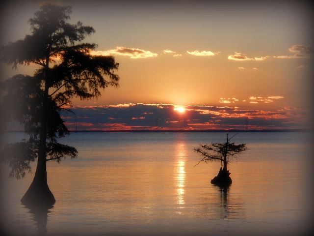
Albemarle Sound, among the richest waters on earth. Photo by Toni Abdnour
Back in time, pretty much everyone who lived on the coastal plain was never very far from a river or creek. But then there was progress, and creeks and marshes became nuisances. They were cast into culverts or grew up as shopping centers or smothered under trash heaps. In a few years nobody remembered they ever existed.
Millions of acres were lost. But here, in this corner of the world, though very much has been lost or altered since colonization, there remains a dynamic, quietly beautiful mosaic of swamp, marsh, river and creek that can teach us a lot about the rhythms of seasons, waters and wildlife, and where, when the moon is hiding, you can still see the glory of a night sky from a wild place.
For centuries, Albemarle Sound and the coastal plain were givers of life to Native Americans and early settlers. This is the story about a land, how it was, how people changed it, and what the future may bring. In many ways it is a reflection of the waves of change that rippled across our country as it became a nation.
Those Devilish Waters
On a clear windless day, when you can see forever across the Sound, you are struck by the beauty and the peace. Do not be fooled. The rages of water have influenced Albemarle history from first discovery.
Albemarle Sound is cradled by a barrier beach that snugs it in, no harbor, no easy port of call. But the ocean outside is relentless, and it is as much a part of the story as the land itself.
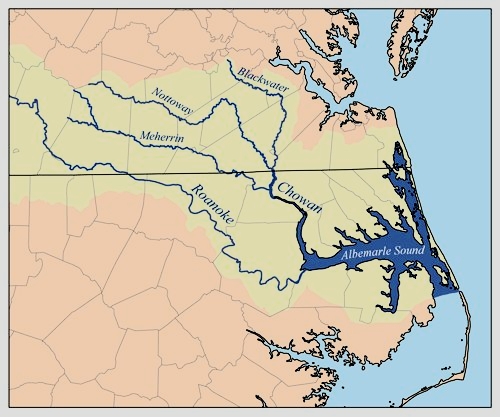
Let’s begin with a few maps to orient you to where and what the Albemarle Sound and its environs are like. The first map shows the area in northeast North Carolina that we will be talking about, tucked directly below the Virginia state line. It is part of a vast, watery system that drains wide swathes of land in two states.

Map of Albemarle Sound and rivers that feed it, from the Virginia border south. South of the Sound lies the Albemarle-Pamlico Peninsula. To the east are the barrier islands called the Outer Banks that flank the Atlantic Ocean. Artwork by Elaine Roth
When explorers sailed up Albemarle Sound in 1586, they rode out gale winds, skirmished with hostile Native Americans and faced near starvation as they navigated the fifty-five mile-long stretch of water. Yet what they found,“freshe water with great store of fishe, pleased them greatly.

The arrival of the English, showing barrier islands with several inlets, Roanoke Island, and the wide Albemarle Sound running toward the top (west). Shipwrecks around inlets were common (noted here as warning to future mariners?) Theodore de Bry engraving from John White watercolor 1590, compiled from voyages 1584-88.
Explorers could not immediately embrace the scope of the waters they were venturing into. Nor could they navigate them today in quite the same way they did 450 years ago.
Waters have risen, islands drowned, shorelines eroded, inlets closed (or opened). This land is a study in quick change. Unlike mountains whose risings and crumblings take eons, change along the coast can take place within our life spans, indeed within moments of our lives.
Let’s pause a moment to look at the dynamics of change before a hurricane comes along to re-arrange land once again. We’ll take a brief look at the rivers in the Albemarle, then we’ll look at the larger picture.
Nine rivers flow into Albemarle Sound. They drain an impressive 18,000 square miles in two states, with 350 miles of navigable water. Unreckoned miles of shoreline along creeks, bays and bottomlands fringe the rivers, quiet hideaways for wonderfully diverse wildlife.
Two of the rivers, the Chowan and the Roanoke contribute most of the fresh water that flows into the Sound. They are fed by tributaries that stretch miles into Virginia, which means that far-distant land uses along them can affect the vitality of the Sound.
Albemarle Watershed with river basins in yellow that extend to Virginia. Pamlico Sound (light blue, not labeled) meets Albemarle Sound at Oregon Inlet. Graphic from Wikipedia, possibly K. Musser 2007
The Sound and its rivers are part of an even larger system. Albemarle Sound merges with Pamlico Sound to the south, which drains 10,000 square miles. Together, the two Sounds and their rivers are known as the Albemarle-Pamlico Estuary.
The entire drainage area of the Albemarle-Pamlico Estuary is 28,000 square miles in two states, an area that’s slightly less than the states of Massachusetts, New Hampshire and Vermont combined.
This estuary is the second largest estuary in the country, a cradle of life, as we shall see.
(Chesapeake Bay in Maryland and Virginia is the largest estuary in the country.)
An estuary is a place where rivers meet the sea, where fresh water and salt water mix. Inlets along the barrier beach give passage to sea water into rivers and sounds.
But inlets are fickle. They can be blasted open by a hurricane or silted in, even displaced by relentless currents.
History records several inlets along the barrier beach. Today, a single inlet, Oregon Inlet, brings salt water into the Albemarle-Pamlico system.
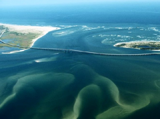
Let’s look a little more closely at this magnificent landmark on the barrier beach.
In 1846 a fierce, slow-moving hurricane carved it open (along with Hatteras Inlet further south). It is named after the first boat that rode out that storm and reported on the new inlet.
Commercial fishermen, recreational fishermen, pleasure cruisers, anyone who knows the inlet say it’s the most treacherous along the east coast. Dredging maintains navigational channels, but they are quickly shoaled in or displaced by unpredictable currents.
Oregon Inlet and its restless shoals, hazardous to fishing vessels and charter boats, has been the target of endless debates about costly jetties and groins to “stabilize” it. This is a classic example of nature holding sway over man. Stay tuned. Oregon Inlet Task Force
Long shore currents are at work, too, propelling Oregon Inlet inexorably south — about two miles in almost two centuries. Long shore currents sliding along the coast at an angle can also close inlets or make them too narrow for navigation.
Before navigational aids, captains often had difficulty locating inlets that may have shifted or closed since their last voyages. Sometimes they were tricked by a mirage of low beach, discovering the error too late.
Graveyard of the Atlantic this watery province is called. With good reason. Latest count: about a thousand ships sunk since 1851. Many more, uncounted, have sunk into oblivion.
There is good reason for this maritime mischief. It’s brewed by a pair of opposing currents that turn rowdy as they round the Outer Banks.
The Gulf Stream begins in Florida and flows north, its warm waters splitting as it heads toward northern Europe or the Canary Islands. The cold-current Labrador originates in the Arctic Ocean and hugs the coast. They meet and do a violent hip-bump around Cape Hatteras, where the barrier island makes an abrupt turn to the southwest.
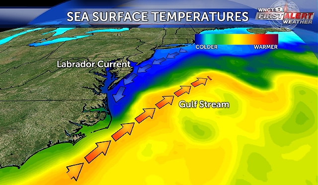
Two currents that skirt the barrier islands cause much of the turbulence in this part of the Atlantic Ocean. WNCT 9 Weather
Diamond Shoals off Cape Hatteras are fearsome waters for ships but fabulous waters for deep sea fishing.
During World War II Germany was well aware of military possibilities off Cape Hatteras, soon to be called Torpedo Junction. In 1942 more than 65 U-boats were deployed to torpedo merchant vessels and their military escorts. Within six months 397 ships were lost with 5,000 souls in this most dangerous place for merchant ships in the world, according to the US Navy.
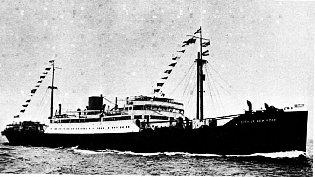
This 452-foot-long passenger-freighter City of New York, torpedoed in 1942, sank in ten minutes. Passengers, including a newborn baby, and crew were rescued by the USS Jesse Roper, a World War I vintage naval destroyer. Photo: National Archives
About now you may be wondering how stormy currents and capricious inlets in the Atlantic might affect life in the Albemarle. Those barrier beaches on the front lines of waves were also barriers to transportation and trade from colonial days on.
There is no fine harbor within the 200-mile stretch from Chesapeake Bay in Virginia to Beaufort in North Carolina.
Captains of sailing ships and steamers could choose the safety of landing in the Chesapeake and the James River, in which case, days of travel south to North Carolina would be added to the journey. Or they could save time and take a chance on maneuvering unpredictable inlets and rough seas. Too often, saving time was not a worthy choice.
And finally, hurricanes stir up the mix with winds, waves, drenching rains, overwash, embedded tornados, storm surge and flooding. Cape Hatteras is the spot on the Atlantic seaboard most targeted by tropical storms and hurricanes. If a hurricane heads for Hatteras, it will surely, in some way, affect the Albemarle region.
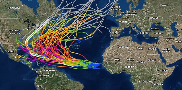
Historical tracks of hurricanes over the past 150 years. NOAA
Each storm leaves a distinct signature. In 2003 Hurricane Isabel drove a path north directly through the Albemarle with 100 mph winds causing massive destruction to crops and farms. Few homes were spared damage from flooding, high winds, or tree falls.
Hurricane Floyd, coming on the heels of Hurricane Dennis in 1999, brought 500-year floods to parts of eastern North Carolina. The record-breaking floods put entire towns underwater and killed 52 people.
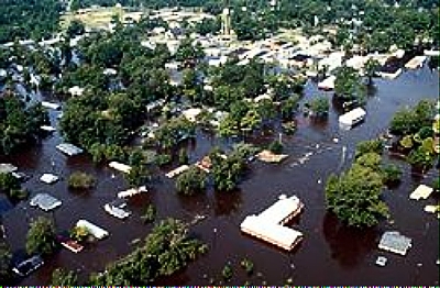
Inland flooding caused by Hurricane Floyd. Aerial photo by J. Jordan of the US Army Corps of Engineers.
If you live through a hurricane you don’t forget it. For a long time afterwards, people tell stories. Such is the case with the San Ciriaco Hurricane of 1899 that first devastated Puerto Rico and then flattened the southern Outer Banks with high winds and flooding before finally limping toward Ireland.
It is considered the worst storm ever to hit the Atlantic coast. Residents had had enough. They packed up their belongings and moved inland, but they still commemorate the anniversary with exhibits, crafts, traditional music and — storytelling.

Rasmus Midgett sits atop the wreckage of the three-masted Priscilla after singlehandedly rescuing ten men from the sinking craft, including three wounded that he had to carry to shore. It is considered the most daring rescue ever. NC Division of Archives photo
By the 18th century several lighthouses warned sailors of dangerous waters. Each lighthouse has its distinctive day-mark, or painted pattern, and night-mark, or beacon pattern. During warm months, hurricanes and tropical cyclones do the battering; nor’easters take over during winter, though there is always the exception.

Hatteras light, the most enduring landmark on the Outer Banks, being moved 2900 feet from the shore in 1999 to avoid the encroaching ocean. Today it lies about 1500 feet from shore. National Park Service photo
Lighthouses weren’t enough. By 1848 life saving stations up and down the beach were manned by heroic crews who, during the worst of weather, rowed repeatedly through crashing waves in small dories to rescue survivors. Later, special boom buoys and motor-driven boats were used. Today, the Chicamacomico Life Saving Station is a museum on the Outer Banks commemorating the heroism of these courageous men.

The all-black crew of the Pea Island Life Saving Station, with their captain, Richard Etheridge far left, who ran a tight company of life-savers. c. 1890. US Coast Guard photo
Now let us take a look at piture-postcard Albemarle Sound to find out why it has never particularly become a sailor’s paradise.
The Sound is governed by sweep of wind, not lunar tide. Winds from the south will drive water to the north, for example, while northerly winds will drive water from the north shore to the south shore. When the winds turn, as they do, and water heads back, the Sound can seem like a sloshing bathtub. When winds run high, this can make for minor but temporary flooding on one side or another.
Depths in the Sound can go from negligible near shore to a maximum of 25 feet. Winds and sudden blows can create choppy seas that turn a pleasure outing into a boater’s distress in a matter of minutes.

A fine day for parasailing above water smooth as glass. But. . .Unattributed, Internet
Albemarle Sound is part of the Atlantic Intracoastal Waterway. Experienced ship captains who must make the short trip across the Sound during their travels have a healthy respect for the Sound’s erratic temperament.
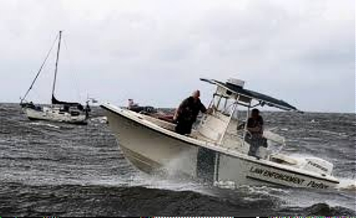
…the Sound can have its rough moments. Here, a sailboat is waiting for rescue. Photo from OBX Today
Near shore, the Sound is threaded with shoals and bars, products of currents and old, drowned shorelines as sea level rose over millennia. Sailing ships must have run aground once too often, because, early on, duties were imposed on ship owners to maintain beacons and stakes in the water as navigational aids.
Marsh and swamp forest buttress the shores, protect the land against storms. Testimony to sunken and eroded shorelines are stranded baldcypress trees. Their seeds germinate on land where they grow best in moist soils.
For a long time, they will tolerate a watery existence, but as sea level rises and water floods the land, waves will continue to erode the shoreline and leave the cypress in deep water until they finally fail.
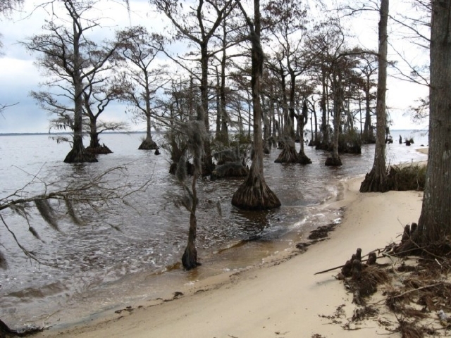
Bald cypress stranded along an eroded beach. Note the gnarled “knees” arising like middle-earth gnomes near trees to the right. Their function is still the subject of speculation. Once they were sawed off for use by arts-and-crafters, but today the practice is illegal. US Fish and Wildlife Service photo
All along the Sound, osprey are attracted to craggy, independent old cypress. Here they build penthouse nests called aeries and raise their young. They return from points south each spring when the shadbush blooms, which means the shad are running and fishing is good. The skies are filled with their aerial displays and high-pitched keening.
They are faithful to the same nest year after year, enlarging and refurbishing until it becomes a mansion in the sky. Unless, of course, their stranded foundation of a cypress creaks and gives way to the watery environment it did not choose in the first place.
Then the osprey must seek a new home and rebuild: another unscripted result of living with the uncertainties of a dynamic environment.
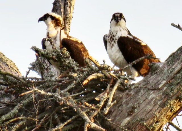
A pair of ospreys on their nest. Photo by Donna Smith
(Next time: Estuaries: Cradle of Life)

such a beautiful place the outer banks trouble is because of this covid nonsense it was crowded in october last year, we went and ended up leaving because it was so crowded you were always dodging people cars and other fishermen. glad they made buxton and places a national seashore so they cant build houses on it.