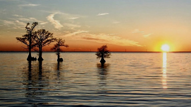
Rising Seas and Sinking Land
Nathaniel Batts may have been a recluse when he died in 1679, but he was a virtuoso wheeler-dealer in his younger days as fur trader, land owner, pardoned murderer, serial debtor, swindler, explorer who discovered an inlet, and friend of people in high places who eased him out of debt when a prenuptial agreement locked him out of his wife’s fortune.
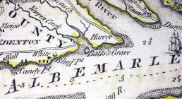
Section of a 1775 map showing Batts Grave at the mouth of of Yeopim Creek
Batt’s colorful life surely deserves a ten-part mini-series, but for now we are more interested in his grave as an expression of what has been lost to rising seas and sinking land.
The North Carolina Gazetteer says that in 1749 the island called Batts Grave was 40 acres in area and had houses and orchards on it. By 1756, in just seven years, it had been reduced to 27 acres.
By mid-twentieth century Batts Grave was reduced to a fly-speck on a map. Today it is gone.
Rising seas, hurricanes and nor’easters ate at the island. Sinking land played a lesser but inexorable role. These geologic forces are continuing today.
In fact, rising and falling seas that seem so dramatic to us today have been changing coastal landscapes for eons.
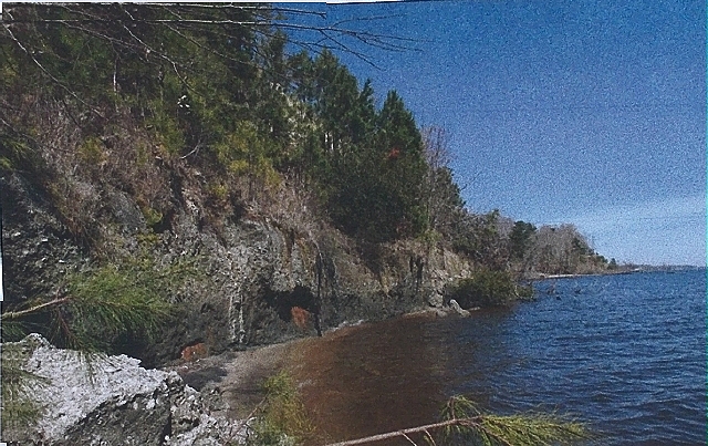
This photo by geologist Stan Riggs pictures a terrace in west Albemarle Sound that was once an old shoreline It adjoins the Suffolk Scarp
The Suffolk Scarp referred to in the caption of this picture is the remains of a shoreline that existed 80,000 to 125,000 years ago, before glaciers sculpted North America, during a warm period when sea level was 25 feet higher than it is today.
At that time the entire Albemarle area was below water, a shallow continental shelf. The barrier islands that we know today did not exist.
The map below shows that, at just a few feet above sea level, the coastal plain (Inner Banks) will flood as polar ice caps melt.
The Suffolk Scarp, or Shoreline, already discussed, is 25 to 50 feet above sea level, but even that will flood if the ocean reaches the Fall Line.
The Fall Line, in black, is where the rolling hills of the Piedmont begin. Interstate 95 generally follows this ridge, which is about 150 feet above sea level today. If both polar ice caps melt, the ocean would rise to the Fall Line.
All land east of the Fall Line would be flooded. Millennia before glaciation, when temperatures were higher and the world was a warmer place, the ocean reached the Fall Line.
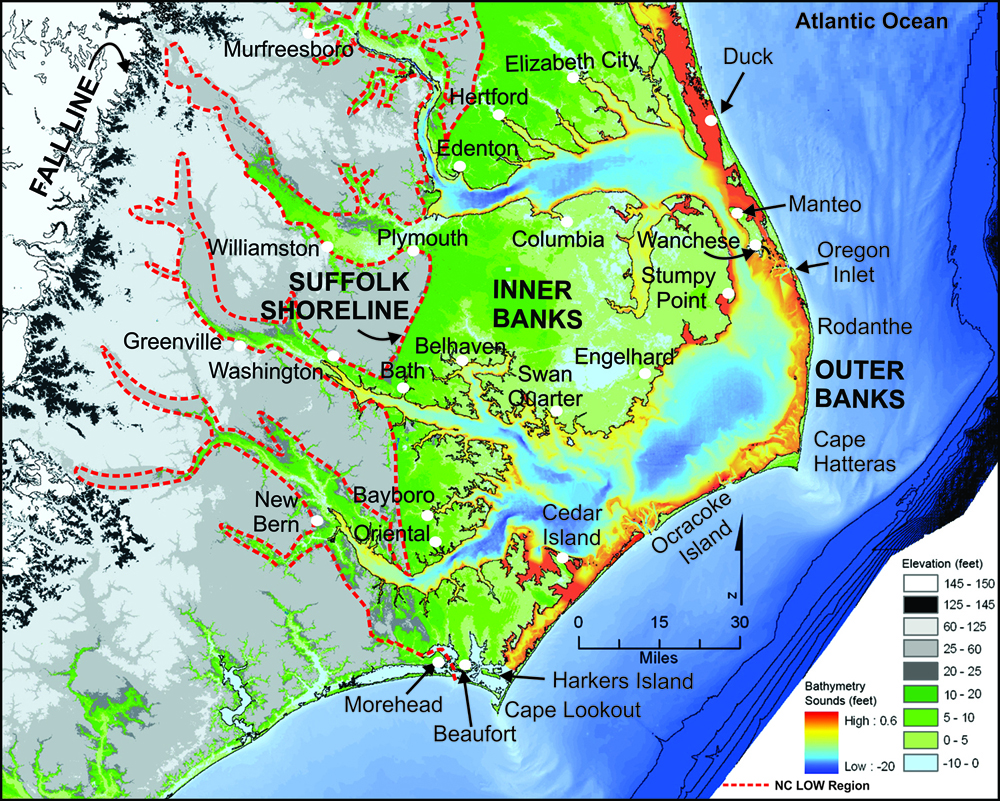
The Albemarle area today showing the coastal plain vulnerable to sea level rise, the old Suffolk Shoreline at 25 to 50 feet above sea level, and the Fall Line (in black) where the rolling hills of the Piedmont begin. NC Land of Water
Our lives are so short we can only observe nannoseconds of geologic change. Interludes of thousands of years of glaciation, when the world was cool and ice caps grew and the level of the ocean dropped. have lulled us into believing that what we experience today is what the land has always looked like. Nothing could be further from reality.
Let’s look more closely at what takes place when glaciers grow. Past glaciation is a major reason why the coastal plain, Albemarle land, is sinking, or subsiding. How can that be, you ask, when this land was never glaciated?
During the last Ice Age, 20,000 years before present, glaciers extended as far south as Long Island. Tons of ice from these glaciers compressed the land beneath. In response, unglaciated land to the south, including the Albemarle, reacted by easing upward. (Like a slo-mo see-saw.)
As climate warmed and glaciers finally melted, the land that had been compressed under them was released and began to rise. Land to the south (the Albemarle) reacted and is still reacting by sinking. (Now the slo-mo see-saw has changed direction downward.)
This action takes centuries. We are only seeing some of the results of this geologic change today, and lately the changes seem to be measured in decades.
Where decades ago, buildings seemed safe, today, there are puddles and flooded streets after storms, worrisome to anyone living in a vintage family home where water now encroaches on the front porch.
But this is only a small part of the story.
Let’s go back in time, say 15,000 years ago when glaciers were beginning to melt, and ocean water is still bound up in glacial ice.
The ocean is about 400 feet lower than today. Land would have extended some fifty miles east of today’s shoreline. A barrier beach, like the Outer Banks, if it existed, would have been just east of that. The Outer Banks, as we know it today, would not form until sea level rose to today’s levels.
The land is tundra-like, but warmer than you might expect because of the Gulf Stream that slides along the periphery. As climate warms, lush marshes and swamps will grow up, wonderful habitat for ice age mammals and birds — and early man.
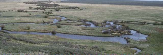
Tundra on the continental shelf miles off today’s shore line? As climate warms, marsh and swamp will develop over thousands of years, then migrate west as sea level rises. NOAA
As the earth warms and sea level rises, the shore line is flooded by the ocean and pushed westward. Marshes are flooded and die and are born anew on higher ground. They replace swamp forests whose trees have drowned but scattered seeds that will take hold on higher, dryer land.
As sea level rises, there is an inexorable migration of water and life to the west.
Fossils of plants and animals and micro fossils of pollen tell stories. By analyzing and carbon dating the kinds of life found in core samples of strata, scientists can read the ancient waves of climate change.
How long did this take? How far out on the continental shelf did early man live? These are questions that cannot easily be answered.
The Albemarle area holds a plethora of fluted points and artifacts, including a dugout canoe from about 6000 years ago. But artifacts of Paleo-Indians could date from 15,000 years ago, or earlier, and these are drowned in open seas today, so we can only imagine the extent of their occupation.
Let’s look at life from the perspective of Early Indians. They were hunter-gatherers who followed the food. They did not have vested interests in real estate and infrastructure.. They accepted what the land had to offer, and moved on when necessary. You could say they were resilient.
It wasn’t necessarily an easy ride. There were great storms and droughts, and floods and freezes and forest fires, even a mini-ice age that lasted almost 1500 years.
Coring on Roanoke Island by the NC Coastal Geology Cooperative reveals a combined rate of sinking land and rising sea level as follows: Only three inches prior to the 19th century. Seven inches by the end of the 19th century. A whopping 16 inches by the end of the 20th century.
Can this be possible? Remember Batts Grave. Our own casual observations of water levels on our bulkhead tell the same story: about 6 to 8 inches rise in thirty-five years.
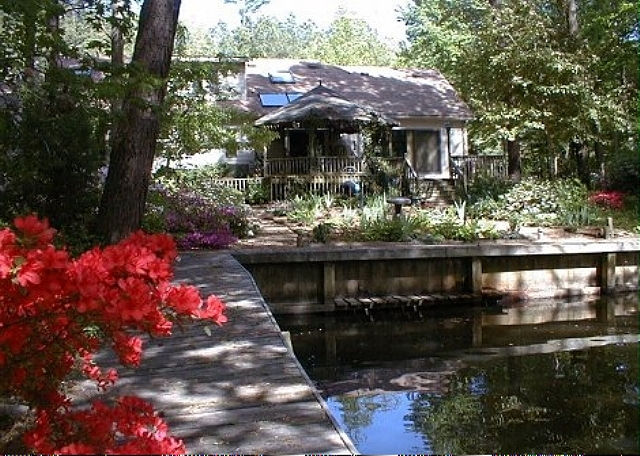
Photo of our boardwalk circa 1988. Note mini-dock we had for disembarking canoes and horizontal timber visible to the right. Today these are totally submerged except on rare occasions when the wind blows steady out of the north and water is pushed to the south. aheronsgarden.com
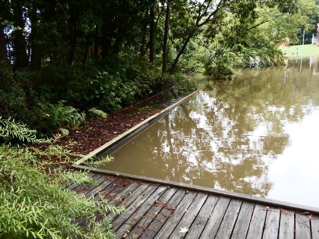
It’s not unusual for a storm to cause water to rise to the top of the bulkhead. After most storms some parts of our woodlands flood. aheronsgarden.com
Albemarle lands are among the most threatened in the country by a combination of subsidence and rising seas.
Do you remember the Suffolk Scarp, or Shoreline in the map above? It rises west of Albemarle Sound and was under water before climate cooled and glaciers froze ocean water and sea level dropped.
Rising seas are expected to reach the Suffolk Scarp in the next 100 to 500 years as climate changes. We are seeing the beginnings today with consistent flooding of roads, farms and yards.
What Do We Do?
Where scientists could not persuade, hurricanes, flooding, loss of low areas and the appearance of ghost forests are turning skeptics into believers in sea level rise.
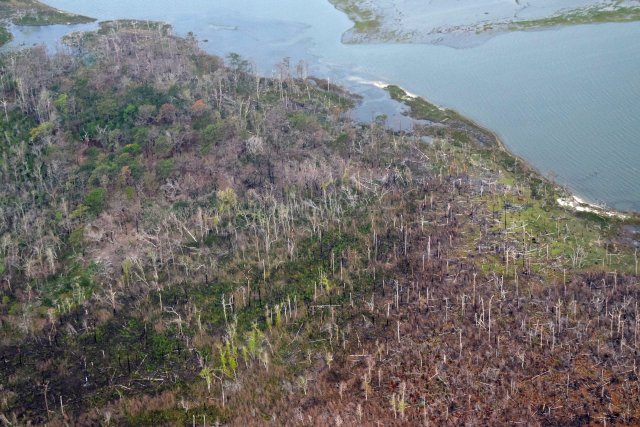
As sea level rises, salt water, from overwash of hurricanes, for instance, can kill plants that are not salt tolerant. These ghost forests are occurring on the Albemarle/Pamlico peninsula today. Mark Hibbs, South Wing SCRO
How will communities respond to threats to their way of life?
We are beginning to realize that we can no longer do battle with rising water and storms. Past knee-jerk reaction has been to harden structures — create seawalls, build jetties, erect bulkheads, pile on the rocks, or the sandbags — to keep that water in its place.

Sand bags scattered on the barrier beach after a storm. Not working too well, judging from the flooding. NC Coastal Federation
Such efforts cannot be maintained in a dynamic environment where change is coin of a watery realm. Water will always win.
Tuning in to the natural world, and working with it, is the best way to preserve our well-being.
All that we have done to the land — ditching, draining, clear cutting the magnificent forests, building dams, laying down pavement — all this speeds up and re-routes the natural flow of water and makes the land — and its people — more vulnerable to the forces of climate.
Spongy wetlands allow water to seep ever so slowly through the landscape. Mighty trees in acres of forests have vast networks of roots that drink copious quantities of water. Once removed, there is erosion and puddles and muck. Ugliness, too.
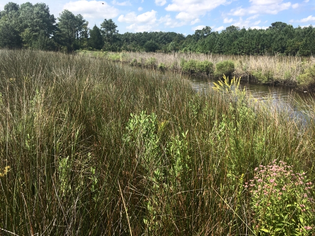
This former farm has been converted to wetlands. Rainfall from the farm once took only two minutes to run off into nearby waters. Now, drainage from these wetlands is naturally slowed, taking more than two months to find its way into creeks. NC Coastal Federation
New ideas must bubble up as scientists, politicians and communities work together. Money is needed to experiment and implement.
Like paleo-Indians we need to develop resilience. We should be working with climate, not against it, treating land as an asset to be managed wisely.
Resilience to storms: Are we just mopping up after storms, or are we making decisions that will reduce future damage?
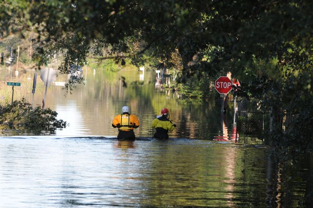
Managing flood waters after Hurricane Matthew. Almost one and a half billion dollars has been spent to clean up after Matthew and Florence alone. Photo by Leticia Samuels, USCG
Communities need help in planning and funding, developing shovel-ready projects that can put fixes in place immediately after a government call for proposals.
Resilience to rising sea level. Close kin of resilience to storms. We need to accept that we can’t prevent sea level rise, but we can develop long-term strategies tailored to sites and community needs.
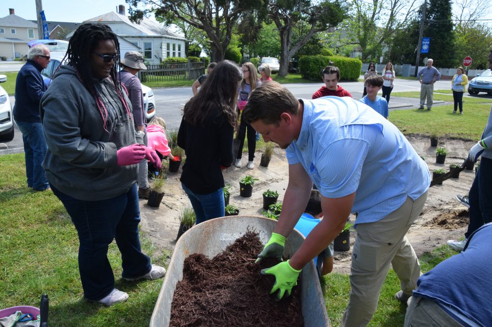
Even small projects like planting a rain garden or an acre of trees will help. NC Coastal Federation
Some examples that emphasize natural solutions:
- moving homes to higher ground
- planting trees whose roots are efficient at absorbing water
- removing impervious pavement
- removing ditches to promote more natural flow of water
- making the ground more spongy so rainwater percolates
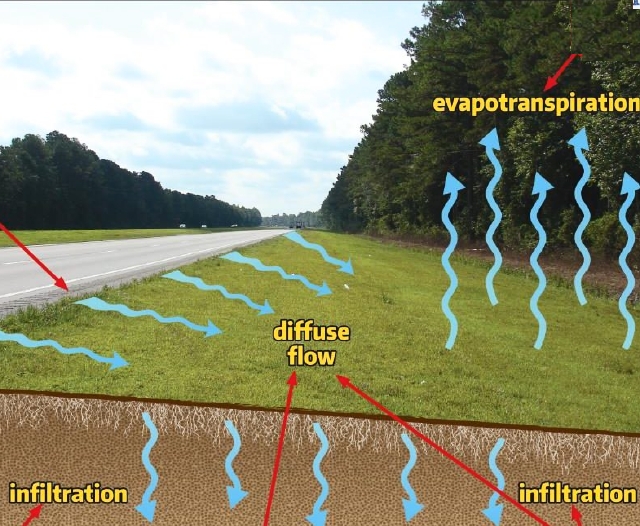
Wide swales on the side of a road diffuse runoff of rainwater and sediment, further helped by woodlands that transpire moisture. On grand scale, this is a technique that would mitigate runoff from miles of impervious roads, driveways and parking lots. NC Dept of Transportation
The mills of government grind slowly. Rising seas care not.
It is up to people brainstorming and barnstorming to find solutions that will protect people and the environment.
Political will. Public-private partnerships. Citizen activism. And community support. These are the tools we need to make sensible plans that will take us into the future.
We can’t know all the answers because we can’t predict the curve balls to come, but with close observation, a thoughtful approach, and cooperative efforts we can develop the resilience that grounded those Paleo-Indians long long ago.
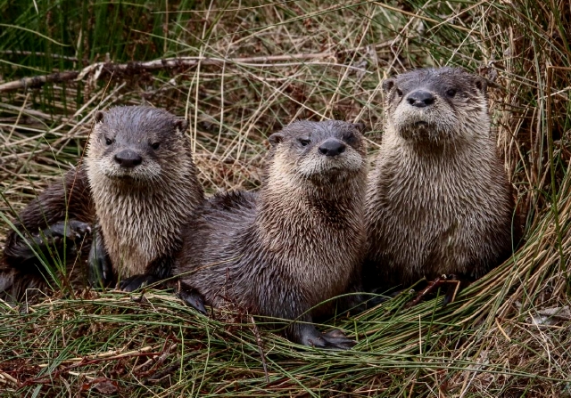
They will thank us. Photo of baby otters by Meekins USFWS
We thank the many career professionals and dedicated volunteers who are helping to protect the Sound, its land and rivers, and its wildlife.
I consulted many on-line sources to frame this Voyage through Centuries: among them, historian David Cecelski whose blog with its wonderful old photographs gives insights to fisheries and everyday life; coastal and marine geologist Stan’s Riggs who tirelessly advocates for a realistic understanding of coastal dynamics and the opportunities they present; and environmentalist Todd Miller, who founded The NC Coastal Federation, a powerful watcher of coastal land and water issues and publisher of Coastal Review Online.
This Voyage grew exponentially out of a grant the Albemarle Environmental Association received from the Albemarle-Pamlico Estuarine Study thirty years ago to produce a series of Profiles of Albemarle Sound and its rivers. The original versions can be found on the website AEA on the Web.